 MAT-SU—The Matanuska River is still pounding away, eroding the riverbank in parts of Butte and Sutton. One property owner’s septic rock is gone, another lost a shed-like cabin into the water over the weekend. Two river rafting companies have suspended trips because of trees swept into the river’s force.
MAT-SU— The Matanuska River is still pounding away, eroding the riverbank in parts of Butte and Sutton. One property owner’s septic rock is gone, another lost a shed-like cabin into the water over the weekend. Two river rafting companies have suspended trips because of trees swept into the river’s force.
Water reached 10.02 feet Saturday morning, two feet below flood stage, according to the NOAA website. (National Oceanic and Atmospheric Administration). The river height is rising and falling, dropping to below nine feet by late afternoon Monday. The debris in the river and the swift current when aimed at soft, silty riverbanks can carve into private property and flow up to a bike path in Butte.
Last week Matanuska-Susitna Borough Manager John Moosey and Assembly Member Warren Keogh visited homes along the river in Sutton. The Glenn Highway in Sutton is at risk for erosion in parts as well. Manager Moosey is looking at pursuing transportation funds to stabilize the riverbank.
Moosey and Keogh also made a conference call to NRCS, Natural Resources Conservation Service with the US Dept. of Agriculture, seeking funds from the Emergency Watershed Protection Program. The program has offered funding to protect property along the Yukon and Kuskokwim Rivers. An engineer visited the river to determine if conditions qualify for federal funding.
In Sutton, the Matanuska River has taken part of Ed and Val Musial’s leach rock for their septic tank at mile 64 of the Glenn Highway. River water is undercutting the leach tank, which is connected to the septic tank. All is encased in concrete. The older couple has said the house will not be livable if the septic goes.
His next door neighbor lost a shed-like cabin into the water over the weekend. The owner has been moving property back from the river's edge.
Saturday night in Butte, a different water body caused trouble for a homeowner at mile 7 of the Old Glenn Highway. Goat Creek had jumped its banks and was flooding the home, according to Casey Cook, Borough Emergency Manager. Sandbags were accepted. The owners diverted the creek away from their home and moved property. By Monday the creek water had receded but ground water was percolating to the surface.
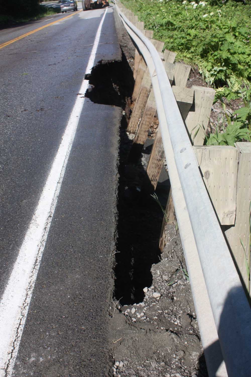
In Butte, Saturday, mile 2 of the Old Glenn Highway was closed for repairs due to swift runoff from snowmelt. Guardrail posts were hanging in mid-air it seemed, due to water flowing over and undercutting the road. A State Dept. of Transportation grader re-graded the ditch and restored the channel for water flow. The road reopened at 2 pm Saturday.
Although it seemed the high water flow was early, apparently it’s typical in the long-term record, according to Janet Curran, hydrologist with USGS Alaska Science Center. She compared this year’s high river flows with historical data. She reports: The Matanuska River can peak from snowmelt (usually May or June), glacier melt (usually later than spring snowmelt, late June or July), or rainfall (typically July, Aug, or Sept). Peaks have occurred in May through September, and are most common in June and July.
Here's the breakdown of month of occurrence for annual peak streamflow:
5% occurred in May
33% occurred in June
40% occurred in July
17% occurred in Aug
5% occurred in Sept
The 2012 streamflow falls within the range of historical flows. The size of the recent peak is about the average value for an annual peak, and the timing of the recent peak is typical of the long-term record, Curran wrote.
For years, the Borough has been working to disseminate information about erosion hazards along the Matanuska River through river management planning, property acquisitions, and erosion hazard mapping.
In 2009 the Alaska Real Estate Commission added a disclosure statement, at the Borough’s request, about erosion to the Real Property Disclosure Transfer Statement so that future buyers along the Matanuska River would be informed of the risks.
Residents in Circle View subdivision pay an extra tax for the five dikes in the river protecting their homes. Water is pounding the dikes, eroding them some, but those homes are not presently threatened.
Photos of septic and tree falling in on Musial property and cabin at river's edge taken by Mark Whisenhunt, Borough Code Compliance Officer. Photos of mile 2 Old Glenn Highway taken by Michelle Olsen, Borough Code Compliance Technician. Photos of flooding at home off Goat Creek taken by Kelsey Akers, Explorer Butte Fire Station.
For more info contact Emergency Manager Casey Cook 373-8800 or Public Affairs Director Patty Sullivan at 745-9577 This email address is being protected from spambots. You need JavaScript enabled to view it.">This email address is being protected from spambots. You need JavaScript enabled to view it.
-end-
—End—
