Benefits of Wetlands
 Wetlands are an important component of the natural resources within the Matanuska-Susitna Borough (Mat-Su). Wetlands link land and water and create valuable and diverse ecosystems. Residents, visitors, and outdoor enthusiasts from around the state enjoy the Mat-Su for its scenery and natural environment which are interrelated and dependent on healthy wetlands and watersheds. Tourism, hunting, and fishing are major economic sectors for the Mat-Su. Fish and wildlife resources and related recreational opportunities contribute to the quality of life for both residents and visitors to the region. The management, conservation and protection of wetlands in the Mat-Su requires a community effort in order to retain the benefits that wetlands provide to us all.
You can learn more from the adopted MSB Wetlands Management Plan HERE.
Developing wetlands requires a permit from the U.S. Army Corps of Engineers - learn more HERE.
Wetlands FactSheets
Land Type in Alaska
A Major Land Type in Alaska
Less than 5 percent of the U.S. consists of wetlands. However, according to the Alaska Department of Environmental Conservation, Alaska contains approximately 63 percent of the nation’s wetlands. Most of the state’s freshwater wetlands (around 100 million acres) are peatlands; however, the state also has marshes, bogs, fens, tundra, and meadows. Another 75 million acres are tidal wetlands and coastal estuaries. Alaska has lost approximately 200,000 acres of wetlands to development activities.
In the Mat-Su, there are 11 wetland types described on the “Identifying Wetlands” page. According to the MSB Wetlands Management Plan, approximately 25 percent of lands in the Mat-Su are wetlands. In the past, wetlands were often considered wastelands or swamps in need of draining or filling. Wetlands are now recognized as highly specialized, valuable and functional components of our environment that need to be managed and protected.
dev/wp-content/uploads/2012/10/Mat-Su-Map-2011-overleaf.jpg" alt="" width="222" height="287" /></p>
Benefits of Wetlands
Wetlands and the activities they support are key to the sustainability of the Mat-Su's economy, lands, and communities.
Lifestyle Benefits:
- Open space
- Clean water
- Recreation opportunities
- Rural character
Economic Benefits:
- Tourism
- Hunting
- Fishing
- Outdoor recreation
- Flood control
- Clean water
- Stormwater management
Environmental Benefits:
- Clean Water
- Flood reduction
- Erosion control
- Habitat for moose, salmon, and waterfowl
- Groundwater recharge and purification
In 2012, the Mat-Su Borough adopted a Wetlands Management Plan to serve as an educational tool and coordination guide for entities involved in wetlands management.
MSB Wetlands Management Plan (see Specialty Plans under Government)
Map Viewer
MAT-SU Wetland Map ViewerThe National Wetlands Inventory (NWI) is a program of the U.S. Fish and Wildlife Service to identify and map wetlands in the United States. In Alaska, the NWI has limited detail, accuracy and coverage. Thus the Mat-Su Borough Planning Department, with funding assistance from the U.S. Fish and Wildlife Service (USFWS) and the U.S. Army Corps of Engineers (Corps), hired contractors to identify and map wetlands more accurately on a local scale. This mapping project included field verification for the central region of the Borough. As of 2011, over 450,000 acres of the Borough have been mapped. This local effort used stereoscopic photography, soils and geologic maps, and site visits involving sediment coring, water chemistry testing, and vegetation sampling to describe and map wetlands.
The Mat-Su Wetlands Maps and links to descriptions and photographs can be found on the Wetlands Parcel Viewer. This electronic map identifies and describes different wetland types over an area of about 450,000 acres between Palmer and Houston. Individual wetlands on the map are linked to descriptions, data, and photographs. The map was created at a scale of 1:18,000, which means a user can zoom in for a much closer view.
Despite the greatly improved accuracy of this updated resource, there are still limitations to the accuracy of the data. The map is useful to identify the extent and types of wetlands in an area, but is not sufficiently detailed to serve as an accurate wetland delineation for regulatory purposes.
For confirmation of wetlands on your property and exact legal boundaries of those wetlands, contact the U.S. Army Corps of Engineers or a qualified wetland delineator.
Map Viewer Tips
On the ArcGIS map viewer, click on the Open button in the middle of your screen just below the picture of the map.

Select the first option, “Open in ArcGIS.com map viewer” from the list of choices.
Depending on your settings, you may see a security warning. Click No to disregard the warning which enables full functionality of the viewer.
The purple features on the map are wetlands mapped by Mike Gracz in 2011, as an update to the pink features, which are wetlands from the National Wetland Inventory dataset.
Use these buttons to see: About this Map, Contents of Map, and Legend.
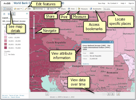
Other features you may want to orient yourself with are shown below.
Use your mouse to pan and use the scale slider bar to zoom and find your area of interest.
ESRI Tips
ArcGIS Online Help
Navigate
To pan and zoom, use your mouse and scroll wheel, the arrow keys on your keyboard, or the zoom slider on the left side of your map. To zoom in, you can also hold down the SHIFT key and drag a box on the map. Click the arrow in the top right corner to open an overview map. You can also navigate the map to a predefined extent through bookmarks.
Tip:
If you have a Mac with OS X 10.6 or greater, you can take advantage of multitouch gestures to pan and zoom the map. The default behavior is to pan. To zoom, press and hold the SHIFT key to zoom in or out. Moving your fingers toward you zooms in; moving your fingers away zooms out.
Locate Specific Places
Use the Find locator to find location ns such as place-names, addresses, intersections, cities, points of interest, monuments, and geographic entities. Your map is automatically zoomed to the closest match from your search, and a callout marker is added to your map. You can remove this by clicking the X in the upper right of the marker.
View Attribute Information
Features are representations such as points or lines of real-world objects drawn on the map. For example, features might represent recreation areas within a national park, emergency evacuation routes, or bird nests within a proposed real estate development project. Features often contain descriptive text, images, and so on, shown in a pop-up window that helps you better understand the significance of a particular map. See About displaying attributes with a pop-up window for more information.
Edit Features
If you see an Edit button, it means the map you are viewing contains a feature layer and you can add, change, or remove the features. See About editing features for more information.
View Data Over Time
If you see a time slider at the bottom of the map, you can play the map to see how the information changes over time. See Viewing time-enabled web maps for more information.
See Map Details
Click the Details button to see information about the map, show the map contents, and see a legend.
About the Map
Click the About button to see a summary, the owner, the last modification date, user ratings, and a link to more detailed information. You also see options to open the map in ArcGIS Explorer Online and make your own map by adding to the existing map or making a new one. If the map includes a presentation created in ArcGIS Explorer Online after March 2, 2011, you will see an option to view the presentation.
Show Contents
Click the Contents button to see a list of the layers in the map. Click the name of the group layer to see the individual layers within the group. Uncheck the box to the right of the name to turn off (not display) the layer. Check the box to the left of the name to turn on (display) the layer. Click the arrow to the right of the layer name and click the Description link to open a web page with detailed information about the layer.
Legend
Click the Legend button to display a legend for the layers in the map. You will not see a legend for basemaps, image layers, or OGC WMS layers. You also will not see a legend for layers that are not accessible externally.
Share
Use the Share button to share a link to a map or embed it in a website or web mapping application. See Sharing web maps for more information.
Click the Print button to create a printer-friendly image of your map. Layers that are not accessible externally, KML, and time-aware layers do not appear on a printed map. If you print a map using your browser print button, many other layers and logos may be missing as well.
Measure
Click the Measure button to determine the area of a polygon, the length of a line, or the coordinates of a point. See Measuring area, distance, and location n for more information.
Access Bookmarks
Click the Bookmarks button to see a list of bookmarks that let you go to a specific location n and scale on the map. See Bookmarking places for more information.
