In early August, one man near Sutton lost part of his house to the scouring Matanuska River. By mid-August, immediate concerns moved downstream near Butte where a revetment near Ye Old River Road began washing away, exposing low-lying areas to seepage.
Some residents hope for 100s of truckloads of big rock to keep the water from chewing off more of the riverbank.
“That may sound like a good idea but the Borough can’t do it,” said Matanuska-Susitna Borough Deputy Mayor Lynne Woods.
“It’s not only a question of money it’s a question of authority. Right now we have no water erosion and flood control powers. We cannot take action by ourselves. That authority rests with the state of Alaska unless a service area is created,” Woods said. “Then state and federal dollars are required and a cooperative effort between the Borough, Legislators, and agencies is needed.”
Woods points to the up-and-coming draft Matanuska River Management Plan, set to be introduced Sept. 7 and scheduled for a public hearing before the Assembly Sept. 21.
In the draft River Management Plan there are options identified by state and federal agencies for managing erosion. “I want to utilize that tool. We need to make an assessment on what’s the best method for addressing erosion. And yes it will require state and federal dollars,” Woods said.
In recent weeks, staff with the Matanuska-Susitna Borough has been monitoring erosion, researching possible federal emergency funding sources, coordinating site visits, briefing local legislative staff, alerting neighbors, and connecting neighbors for collaboration, among other efforts.
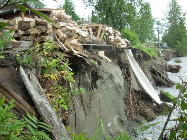
The revetment is an embankment, built parallel to the riverbank originally 2,000 feet long to protect low-lying areas from flooding.
Built by the Alaska Dept. of Transportation in the 1980s, the revetment extends from Maud Road south past Ye Old River Road.
Today, most of the armour rock—massive boulders 3,000 pounds or more in size—has scoured off the revetment. Only a gravel berm remains with two holes punched through it. Though ownership of the revetment is unclear, it has not been accepted by the Borough for maintenance and has not been maintained by the State Dept. of Transportation. View a map of erosion near the revetment from 1978 to 2004 by clicking.
A dozen homes are nearby. More than half the land at risk for erosion is Borough-owned land. No imminent danger exists, said Tom Smayda, Borough Emergency Manager. Residents are concerned about future flooding of their property and seek funding for erosion structures. Funding is not easy to secure and not cheap.
For example, to build a structure about 3.5 miles long from the George Palmer bridge on the Old Glenn Highway (mile 17) to just north of the Falk Lake area, (mile 13) has initial cost estimates at $8.5 million per mile or $30 million to construct and $172,000 annually to maintain the structure.
Early estimates on rebuilding just the revetment could rise to $4 million.
The State-maintained Old Glenn Highway is nearby. Another protective structure is on land, 1,000 feet from the river. It’s a levee several thousand feet long, which was built parallel to the Old Glenn Highway.
The Matanuska River is owned by the state. Rigorous state and federal permit processes are required to build in it. The establishment of a community service area is required before the Borough can undertake any construction in the river. The effort is expensive. The last dike for property owners in the Circle View & Stampede Estates service area cost some $580,000 of federal dollars. Since that construction the Borough has begun focusing on non-structural solutions such as buyouts, in part, because agencies prefer that. Maintenance of structures is costly.
In 2007, the Borough lined up $500,000 in state and federal funds to buy out three properties near Sutton. But such funds are hard to find. In Sutton there are some 20 buildings that are between the Glenn Highway and the Matanuska River, some of them at risk.
Flood insurance is available to property owners through the National Flood Insurance Program.
Borough staff will continue to research federal and state funding options.
Educating newcomers about the hazards of the destructive river and helping existing property owners along the river has been the ongoing work of the Borough.
Other tools include a mapping study. Nearly complete the study has mapped the erosion risk areas on the Matanuska River. The Borough matched $500,000 with the U.S. Geological Survey’s $500,000 for the study.
“This will show people when they come in to build and ask for a land use permit where erosion risk areas are,” said Borough Planner Frankie Barker.
The Matanuska River passes through 80 miles from the toe of the Matanuska Glacier to the wide flat valley at Knik River.
The river erodes riverbanks so aggressively because it is loaded with glacial sediment and rock. The U.S. Geologic Survey estimates the average annual riverbed load yield in the lower portions of the Matanuska River near Palmer to be 397,000 tons, or 267,000 cubic yards. The riverbed load is the material carried by a river, either suspended in the water or rolled along the riverbed.
For more information call Borough Public Affairs Director Patty Sullivan at 355-0103 or This email address is being protected from spambots. You need JavaScript enabled to view it..
—End—